

Treeathlon Course and Venue Map
We are excited to introduce Treeathlon’s new 2026 course at Seal Point Park in San Mateo. The transition zone and event area are situated on a small hill overlooking the Bay, with views of the Santa Cruz Mountains, the San Francisco skyline, and nearly the entire race course — making Treeathlon especially spectator-friendly this year. Aside from short inclines to and from the transition area, both the bike and run courses are flat and fast. The swim takes place in the Bay, the run follows the scenic Bay Trail along the waterfront, and the bike course consists of four laps on J. Hart Clinton Drive. The course is the same for the Draft-Legal and the Classic races.
Interactive Map
Click HERE for our interactive, zoomable map of the race course and event plaza. Below are descriptions of each race segment.
Swim
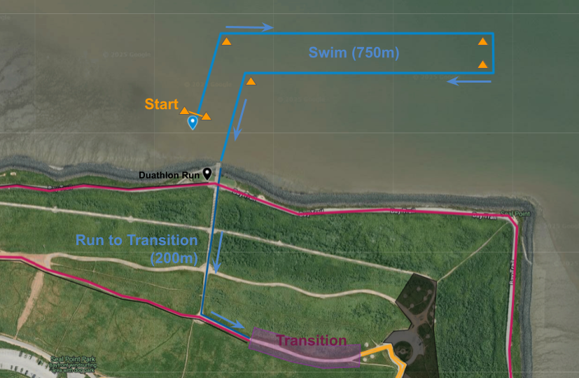
The Treeathlon swim course (750 m) starts in the water just off the watersports access ramp at Seal Point Park. Swimmers will proceed clockwise, leaving three buoys on their right and the final buoy on their left. Athletes will exit the water via a ladder at the same access ramp and run up a short stairway to the transition zone (approximately 200 m). They enter the transition zone from the west.
If water temperatures or the weather do not allow for a swim, the swim segment will be replaced by a 2km run. This Duathlon Run will also start at the access ramp to the west, and end at the transition zone. The subsequent bike segment (20km) and run segment (5km) remain unchanged.
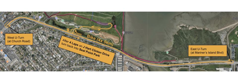
Bike
For the bike course (20km), athletes leave the transition zone at the east end and mount immediately after the mount line. The course leads downhill toward J. Hart Clinton Drive; athletes are advised to exercise increased caution and maintain an appropriate speed on this short descent. Athletes then turn right onto J. Hart Clinton Drive. After completing 4 laps, athletes make a right turn to re-enter Seal Point Park. A short climb concludes the bike course. Athletes dismount before the dismount line and enter the transition zone through the east entrance.
Run
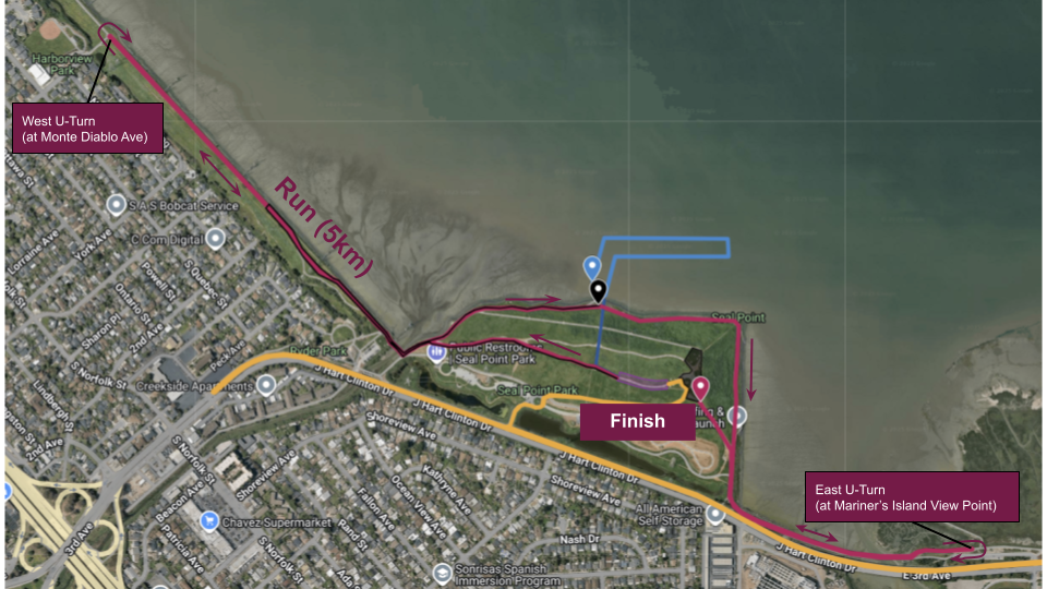
The run course (5 km) leads west from the transition area, following a gravel path that turns into asphalt at the foot of Seal Point Hill. Runners cross the San Mateo Creek pedestrian bridge, follow the Bay Trail, and turn around at Monte Diablo Avenue. After crossing back into Seal Point Park, runners continue along the Bay Trail around the park and make their way to the eastern turnaround at Mariner’s Point. Returning to Seal Point Park, the finish line will soon be in sight. There are no laps on the run course.
Transition and Event Plaza
The transition zone is located in the center of Seal Point Park, on a small hill. Coming from the swim, athletes enter the transition zone through the west gate and exit through the east gate for the bike segment. After completing the bike segment, athletes re-enter the transition zone through the east gate and exit through the west gate for the run. The finish line is located directly across from the transition zone and features a short uphill finish chute.
Around the roundabout, tables for the EMTs, packet pickup, timing staff, race directors, volunteer check-in, and the post-race expo will be located. Restrooms are available in the lower parking lots. Spectators are welcome to view the race from anywhere in the park; however, we kindly ask that they remain off the race course.
Water quality results for 2026: Feb 9, 2026